What is actually being proposed, and how to make your voice heard!
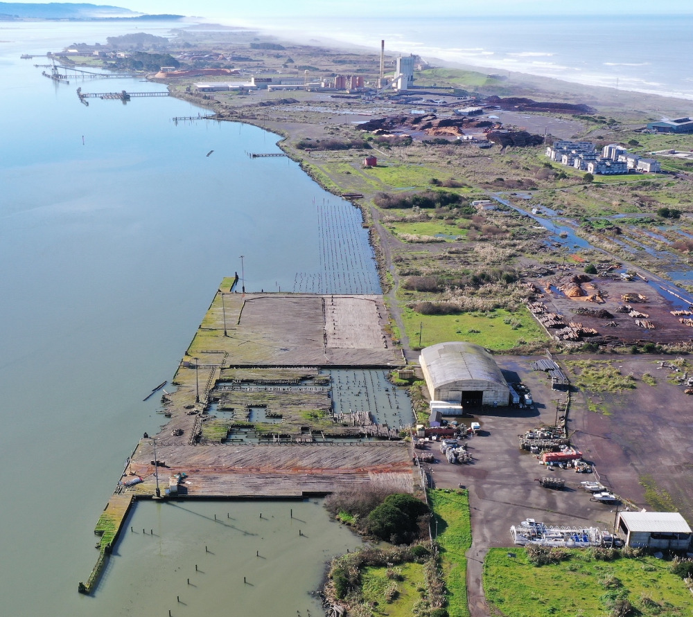 Humboldt Waterkeeper has been studying the proposed Humboldt Bay Offshore Wind Heavy Lift Marine Terminal on the Samoa Peninsula for several years, with a focus on its potential impacts on Humboldt Bay — known to Wiyot people as Wigi — and the surrounding communities.
The project site, known as Redwood Marine Terminal I. Drone image by Oren Nardi.
Understanding what is being proposed is the first step to understand the project's impacts. We developed this brief summary of the latest project description to help people think about how the project would impact the bay ecosystem, water quality, and people with various relationships with the bay. In the coming weeks, we'll be developing comments as we continue to research the impacts of the project components. The Harbor District is now calling for input on the project: impacts that should be analyzed, as well as alternatives and mitigation measures that should be considered to lessen those impacts. ENVIRONMENTAL REVIEW PROCESS AND KEY DATESThe Notice of Preparation of a Draft Environmental Impact Report (EIR) was recently released for a 60-day public review period. The NOP contains the complete Project Description, with figures that are posted separately.A public scoping meeting will be held on Nov. 4 at 5:30 pm at the Eureka Veterans Memorial Hall, 1018 H Street, Eureka, CA 95501. Oral comments will be limited to 90 seconds: not much time, so be prepared to make your position as clear, concise, and direct as you can!Written comments are due at 5 pm on Dec. 7 via email to- What potential impacts should be considered in the Draft Environmental Impact Report?
- What mitigation measures and project alternatives should be considered and analyzed?
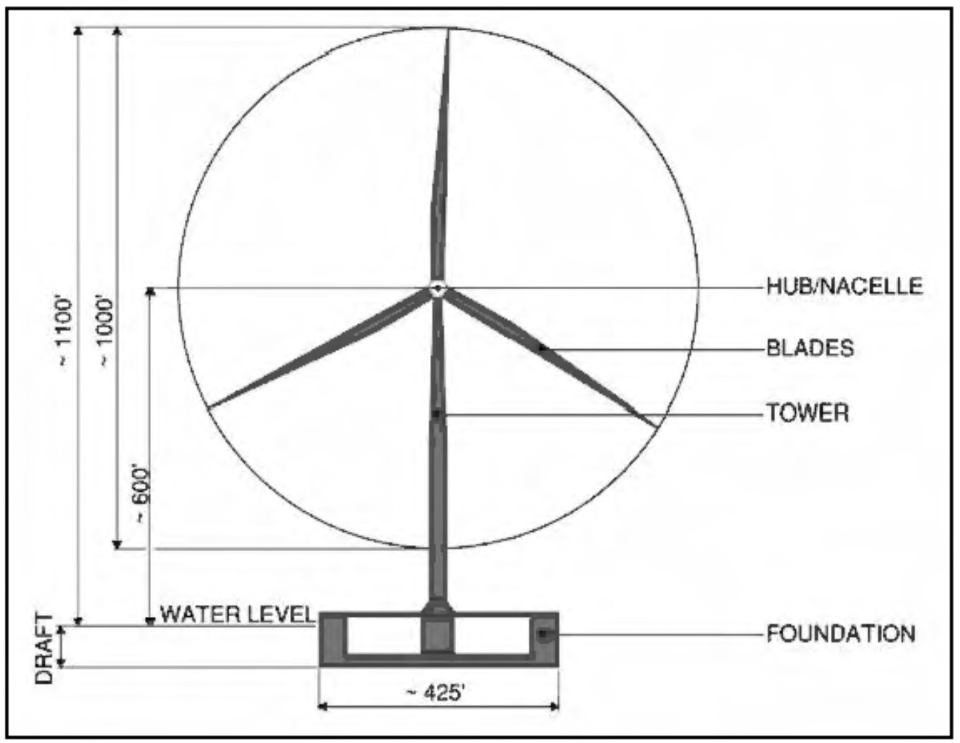 The project contemplates assembling 15-20 MW wind turbines that would be between 950 and 1,050 feet tall at the tip of the blades during rotation. Three blades 300-450 feet long would be attached to the nacelles (the power-generating components at the center of the blades) approx. 550-600 feet in elevation. For comparison, the former Evergreeen pulp mill smokestack is approx. 300' tall. Above: Diagram of a 20 MW floating offshore wind turbine (Humboldt Bay Harbor District, 2023).Floating foundations made of either steel or concrete would be up to 450 feet long, up to 100 feet tall, and would weigh between 500 and 2,000 tons. Bay water will be used as ballast to stabilize floating foundations during turbine assembly, wet storage, tow-out for installation in the offshore Wind Energy Area 21-29 miles offshore, and tow-in for future maintenance.
SUMMARY OF THE PROJECT DESCRIPTION
The project would include the following activities:Relocating Existing Businesses- Commercial fishing gear would be moved to Woodley Island.
- Two shellfish farms, one seaweed farm, and a hagfish (slime eel) holding facility would be moved off-site to as-yet unidentified locations.
- The extent of contamination from past industrial uses across the 180-acre site will be identified with a grant from the U.S. EPA’s Brownfield Program. Contaminants include dioxins and furans, metals, petroleum products, PCBs, mercury, etc. Extensive sampling will be done, followed by a cleanup plan to be funded by a future grant.
- Sampling of bay sediments has begun in the areas proposed for dredging, revealing dioxin contamination near the old Louisiana-Pacific dock near the Samoa Bridge. Contaminated dredge spoils will need to be taken to a hazardous waste landfill. Sediments with very low levels of contamination would likely be dumped offshore, but clean sandy material could potentially be used for beach replenishment at eroded sites on the North Spit.
- 6.25 million cubic yards of bay sediment would be dredged to create a 60-foot-deep “sinking basin” for launching the wind turbines’ floating foundations, as well as temporary “wet storage” sites near Tuluwat where assembled turbines will sit waiting to be towed to sea.
- Approx. 124,000 cubic yards would need to be dredged every 4 years (depending on how much material accumulates).
- Eelgrass beds in the areas to be dredged would be destroyed (approx. 5-9 acres).
- The North Wharf: 1700’ long by 150’ wide with 1,950 piles.
- The South Wharf: 1800’ long by 150’ wide with 2,065 piles.
- Each would have thirty 40’ by 40’ near-shore mooring dolphins.
- Lighting may be required for navigational safety, although this is not mentioned in the NOP.
- Two wet-storage areas will be dredged to depths of -38 ft. between Tuluwat Island and the Samoa navigation channel.
- The 45-acre North area will accommodate up to 2 floating foundations. The 71-acre South area will accommodate up to 7 floating foundations or assembled wind turbines.
- Approx. 200 piles will be driven to support berths made up of two 40 x 200 ft. platforms with 15 x 15 ft. concrete decks to temporarily stage floating foundations and assembled wind turbines before being towed to sea (see Figure 17).
- In the South area, diesel generators will be required to slowly turn the rotors to prevent internal damage while in wet storage and while towing out to sea.
- Lighting may be required on the wet storage structure, the assembled turbines, and the foundations, although this is not mentioned in the NOP.
- 150-foot-tall high-mast lighting poles with 4-6 luminaires will be designed to meet DarkSky International Port Marine Terminal guidelines.
- “The lighting design shall confine and direct light to its respective work zone. At least 90 percent of the total lumens emitted by the lighting system shall be contained within the designated work zones to minimize light trespass and unnecessary illumination outside the operational areas.”
- A sanitary sewer system to convey wastewater to the Samoa Wastewater Treatment Facility with up to 2 onsite lift stations will be installed to service the three proposed buildings.
- Domestic water supply from the Mad River to be stored in an approximately 510,000 gallon tank on the site.
- New stormwater features to collect runoff, including a combination of underground infiltration galleries, bioretention facilities, and treatment control to treat stormwater runoff and to intercept trash.
- Backup 60-kV transmission lines, two substations and a microgrid;
- A 300-kW rooftop solar array, 1.9-MW battery-storage systems and 2-MW emergency generators for each phase, and a 2.5-MW solar system at the nearby Louisiana-Pacific Samoa solid waste landfill.
- A 2 MW diesel backup generator for the terminal site, plus mobile diesel generators to power the wind turbines in temporary “wet storage” near Tuluwat Island.
A new 1.2-mile bike path within the Great Redwood Trail Agency corridor.
A “Waterfront Recreation Center” on Woodley Island (although it is not on the waterfront).
Offshore Wind Terminal Operations: This section lacks specifics, although it would be ongoing for 30-35 years after construction.- General “staging and integration” operations, including the use of crawler cranes and two fixed position quayside ring cranes; loading and unloading of turbine components via ships, such as blades, towers, floating foundations, and mooring equipment, such as anchors, mooring lines, and chains.
- Tow-out of assembled wind turbines is not described in the NOP. Descriptions of tow-out operations at various public meetings have included “rolling closures” of the navigational channels to other vessel traffic during tow-out.
- Maintenance and repair of wind turbines is likely to occur at the Heavy Lift Marine Terminal, but is not mentioned in the NOP.
- Decommissioning of the terminal is not considered in the NOP.
- 2028–2029: Improving North and West Access Roads, demolition, onsite improvements, offsite improvements on Woodley Island, and constructing the onsite mitigation/habitat restoration area;
- 2029–2034: Majority of on site development, create sinking basin, soil improvements, construction of full 1,700 ft North Wharf and partial (600 ft) of Southern Wharf; and
- 2035–2037: Developing electrical infrastructure and construction of the remaining 1,200 ft of Southern Wharf.